sitelen:EGY orthographic.svg
Jump to navigation
Jump to search


Size of this PNG preview of this SVG file: 550 × 550 pixels. suli ante: 240 × 240 pixels | 480 × 480 pixels | 768 × 768 pixels | 1,024 × 1,024 pixels | 2,048 × 2,048 pixels
ijo nanpa wan (SVG file, nominally 550 × 550 pixels, file size: 1.35 MB)
ante li seme
| Description |
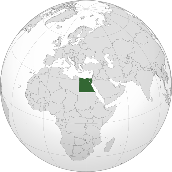
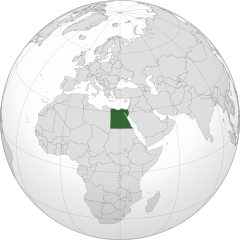
English: Orthographic map of Egypt centered at 26° N, 30º E.
Official territory.
Claimed territories. |
| nanpa tenpo | |
| Source |
Own work with Natural Earth Data This W3C-unspecified vector image was created with Inkscape . |
| jan sitelen | Addicted04 |
Licensing
I, the copyright holder of this work, hereby publish it under the following license:
This file is licensed under the Creative Commons Attribution-Share Alike 3.0 Unported license.
- You are free:
- to share – to copy, distribute and transmit the work
- to remix – to adapt the work
- Under the following conditions:
- attribution – You must give appropriate credit, provide a link to the license, and indicate if changes were made. You may do so in any reasonable manner, but not in any way that suggests the licensor endorses you or your use.
- share alike – If you remix, transform, or build upon the material, you must distribute your contributions under the same or compatible license as the original.
tenpo pini pi ijo ni
Click on a date/time to view the file as it appeared at that time.
| tenpo | sitelen lili | suli | jan | o toki | |
|---|---|---|---|---|---|
| current | 2022-09-09T19:26:43 | | 550 × 550 (1.35 MB) | wikimediacommons>Salma3232 | Reverted to version as of 01:19, 11 January 2022 (UTC) |
kepeken pi lipu nanpa ni
The following page uses this file: