sitelen:Mali (orthographic projection).svg
tan lipu Wikipesija
Jump to navigation
Jump to search

Size of this PNG preview of this SVG file: 550 × 550 pixels. suli ante: 240 × 240 pixels | 480 × 480 pixels | 768 × 768 pixels | 1,024 × 1,024 pixels | 2,048 × 2,048 pixels
ijo nanpa wan (SVG file, nominally 550 × 550 pixels, file size: 83 KB)
This file is from Wikimedia Commons and may be used by other projects. The description on its file description page there is shown below.
je besoin de kate
ante li seme
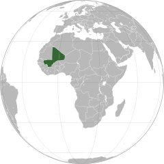
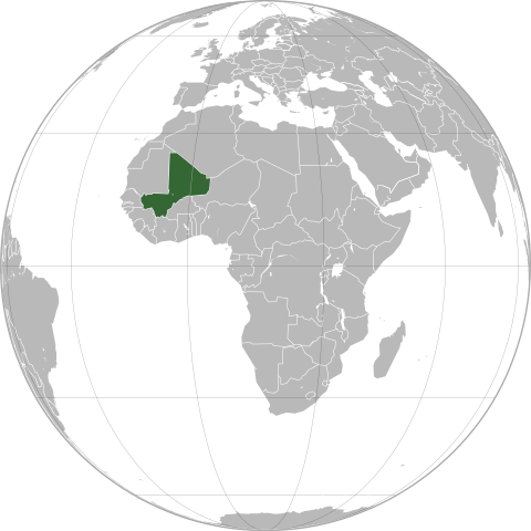
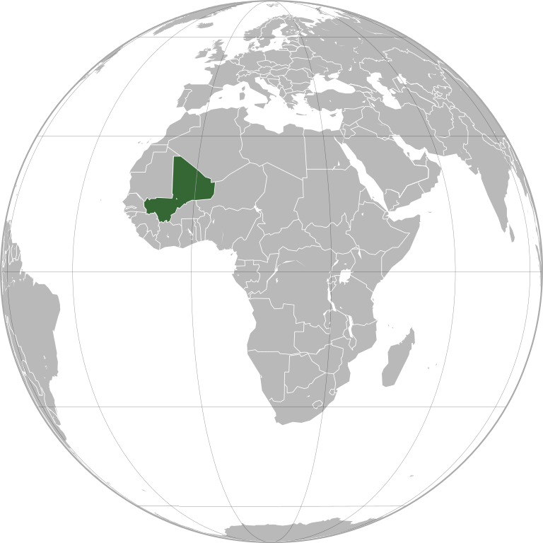
| DescriptionMali (orthographic projection).svg |
English: Mali (orthographic projection)
Português: Mali (projeção ortográfica)
Español: Mali (proyección ortográfica) |
|||
| nanpa tenpo | ||||
| Source | Own work | |||
| jan sitelen | Marcos Elias de Oliveira Júnior | |||
| Permission (Reusing this file) |
|
|||
| Other versions |
|
.svg)
.svg)
العربية: الرجاء، قراءة الميثاق.
বাংলা: দয়া করে, রীতিনীতিটি পড়ুন।
Deutsch: Bitte lies die Konventionen.
English: Please, read the conventions.
Español: Por favor, lea las convenciones.
Filipino: Paki-basa ang mga kumbensyon.
Français : S'il vous plaît, lisez les conventions.
हिन्दी: कृपया सभागमों को पढ़ लें.
Bahasa Indonesia: Silakan, baca konvensi.
Italiano: Si prega di leggere le convenzioni.
日本語: 規約をご確認ください。
ქართული: გთხოვთ, გაეცნოთ კონვენციებს.
Македонски: Ве молиме, прочитајте ги општоприфатените правила.
Português: Por favor, leia as convenções.
Русский: Пожалуйста, прочитайте соглашения.
Tagalog: Paki-basa ang mga kumbensyon.
Українська: Будь ласка, прочитайте конвенції.
Tiếng Việt: Hãy đọc công văn trước khi đăng.
| World maps |
|---|
Africaहिन्दी: अफ्रीका
ქართული: აფრიკა.
Eastern Africaहिन्दी: पूर्वी अफ्रीका
Southern Africa
Central Africa
Northern Africa
Western Africa
Americasქართული: ამერიკა.
हिन्दी: अमेरिका
North Americaहिन्दी: उत्तरी अमेरिका
Central America
Caribbean
South Americaहिन्दी: दक्षिण अमेरिका
Asiaहिन्दी: एशिया (जम्भूद्वीप)
ქართული: აზია.
Português: Ásia.
Українська: Азія.
Eastहिन्दी: पूर्वी एशिया
ქართული: აღმოსავლეთი აზია.
Português: Ásia Oriental.
Українська: Східна Азія.
Centralहिन्दी: मध्य एशिया
ქართული: ცენტრალური აზია.
Português: Ásia Central.
Українська: Центральна Азія.
SoutheastFilipino: Timog-silangang Asya.
हिन्दी: दक्षिण-पूर्वी एशिया
Bahasa Indonesia: Asia tenggara
ქართული: სამხრეთ-აღმოსავლეთი აზია.
Português: Sudeste Asiático.
Tagalog: Timog-silangang Asya.
Українська: Південно-Східна Азія.
Southहिन्दी: दक्षिण एशिया (भारतीय उपमहाद्वीप)
ქართული: სამხრეთი აზია.
Português: Sul da Ásia.
Українська: Південна Азія.
Westernहिन्दी: पश्चिमी एशिया
ქართული: დასავლეთ აზია.
Português: Sudoeste da Ásia.
Українська: Передня Азія.
Europeहिन्दी: यूरोप
ქართული: ევროპა.
Português: Europa.
Română: Europa.
Русский: Европа.
Українська: Європа.
Countries
Oceaniaहिन्दी: ओशिआनिया
ქართული: ოკეანეთი.
Português: Oceania.
Українська: Океанія.
Intercontinentalहिन्दी: अंतर्महाद्वीपिय
ქართული: კონტინენთშორისი.
Português: Intercontinental.
Українська: Міжконтинентальні.
HistoricalEnglish: Unions, Organizations, Kingdoms, Empires
Español: Uniones, Organizaciones, Reinos, Imperios
Filipino: Mga Unyon, Organisasyon, Kaharian, Imperyo
Français : Unions, Organisations, Royaumes, Empires
हिन्दी: संघ, संगठन, राज्य, साम्राज्य व ऐतिहासिक देश
ქართული: გაერთიანებები, ორგანიზაციები, სამეფოები, იმპერიები
Português: Estados extintos.
Tagalog: Mga Unyon, Organisasyon, Kaharian, Imperyo
Українська: Союзи, Організації, Королівства, Імперії
Subnationalsहिन्दी: उपराष्ट्रीय इकाईयाँ
ქართული: სუბეროვნული ერთეულები.
Português: Entidades subnacionais.
Українська: Субнаціональні утворення.
|
.svg)
.svg)
.svg)
.svg)
.svg)
.svg)
.svg)
.svg)
.svg)
.svg)
.svg)
.svg)
.svg)
.svg)
.svg)
.svg)
.svg)
.svg)
.svg)
.svg)
.svg)
.svg)
.svg)
.svg)
.svg)
.svg)
.svg)
.svg)
.svg)
.svg)
.svg)
.svg)
.svg)
.svg)
.svg)
.svg)
.svg)
.svg)
.svg)
.svg)
.svg)
.svg)
.svg)
.svg)
.svg)
.svg)
.svg)
.svg)
.svg)
.svg)
.svg)
.svg)
.svg)
.svg)
.svg)
.svg)
.svg)
.svg)
.svg)
.svg)
.svg)
.svg)
.svg)
.svg)
.svg)
.svg)
.svg)
.svg)
.svg)
.svg)
.svg)
.svg)

.svg)

.svg)

.svg)
.svg)
.svg)
.svg)
.svg)
.svg)
.svg)


.svg)
.svg)
.svg)
.svg)
.svg)
.svg)
.svg)

.svg)
.svg)
.svg)
.svg)
.svg)
.svg)
.svg)
.svg)
.svg)

.svg)
.svg)
.svg)
.svg)
.svg)
.svg)
.svg)
_without_national_boundaries.svg)
.svg)
.svg)
.svg)
.svg)
.svg)
.svg)

.svg)
.svg)
.png)
.svg)
.svg)
.svg)
.svg)

.svg)
.svg)
.svg)
.svg)
.svg)
.svg)
.svg)
.svg)
.svg)
.svg)
.svg)

.svg)
.svg)
.svg)
.svg)
.svg)
.svg)
.svg)
.svg)
.svg)

.svg)
.svg)

.svg)
.svg)
.svg)
.svg)
.svg)
.svg)
.svg)
.svg)
.svg)
.svg)
.svg)
.svg)
.svg)
.svg)
.svg)
.svg)
.svg)
.svg)
.svg)
.svg)
.svg)
.svg)
.svg)
.svg)
.svg)
.svg)
.svg)
_-_Crimea_disputed.svg)
.svg)
.svg)
.svg)
.svg)
.svg)
.svg)
.svg)
.svg)
.svg)
.svg)
.svg)
_political.svg)
.svg)
.svg)
.svg)
.svg)
_-_Crimea_disputed_-_no_borders.svg)
.svg)
.svg)
.svg)
.svg)
.svg)
.svg)
.svg)
.svg)
.svg)
.svg)
.svg)

.svg)
.svg)
.svg)

.png)
.svg)
.svg)
.svg)
.svg)
.svg)
.svg)
.svg)
.svg)
.svg)
.svg)
.svg)
.svg)
.svg)
.svg)
.svg)
.svg)
.svg)
.svg)
.svg)
.svg)
.svg)
.svg)
.svg)
.svg)
.svg)
.svg)
.svg)
.svg)
.svg)
.svg)
.svg)
.svg)
.svg)
.svg)
.png)
.svg)
.svg)
.svg)
_(orthographic_projection).png)
.svg)
| Orthographic projections maps created by Ssolbergj |
|---|
| Orthographic projections maps created by Ssolbergj: |
.svg)
.svg)
Captions
Add a one-line explanation of what this file represents
Carte Malienne sur la Carte Mondiale
creator toki Inli
some value
copyright status toki Inli
copyright license toki Inli
source of file toki Inli
original creation by uploader toki Inli
inception toki Inli
17 tenpo mun #6 2011
tenpo pini pi ijo ni
Click on a date/time to view the file as it appeared at that time.
| tenpo | sitelen lili | suli | jan | o toki | |
|---|---|---|---|---|---|
| current | 2022-07-18T22:04:52 | | 550 × 550 (83 KB) | wikimediacommons>M.Bitton | added the missing border between Ethiopia and Eritrea, per request |
kepeken pi lipu nanpa ni
The following page uses this file:
Metadata
This file contains additional information, probably added from the digital camera or scanner used to create or digitize it.
If the file has been modified from its original state, some details may not fully reflect the modified file.
| Width | 550 |
|---|---|
| Height | 550 |
.svg)