sitelen:12 tribus de Israel.svg
Jump to navigation
Jump to search


Size of this PNG preview of this SVG file: 394 × 600 pixels. suli ante: 158 × 240 pixels | 315 × 480 pixels | 504 × 768 pixels | 673 × 1,024 pixels | 1,346 × 2,048 pixels | 2,313 × 3,520 pixels
ijo nanpa wan (SVG file, nominally 2,313 × 3,520 pixels, file size: 1.19 MB)
Quiero está foto a en formato svg
ante li seme
| Description |
[]
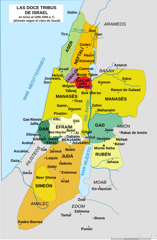
English: Map of the territories allotted to the "twelve tribes of Israel" according to the Book of Joshua, chapters 13–19, before the move of Dan to the North. Note that these territories were only allegedly allotted to said tribes, and the texts themselves indicate that the tribes had troubles conquering all these areas and cities from the native peoples. The Biblical account may also be far from historically accurate, and has been disputed by scholars. Nederlands: Kaart van de gebieden van de 12 stammen van Israël. Português: Mapa das 12 tribos de Israel Македонски: Карта на дванаесетте Израилеви племиња во Библијата, пред преселбата на Дановото племе на север Українська: 12 племен Ізраїля 中文(简体): 以色列十二支派地圖。 中文(繁體): 以色列十二支派地圖。 اردو : اسرائیل کے بارہ قبائل کا نقشہ العربية : خريطة للأراضي التي حُصصت لأسباط إسرائيل الاثني عشر حسب الإصحاحات 13-19 من كتاب يشوع قبل أن يتحرك دان نحو الشمال. النص الكتابي قد يكون غير دقيق تاريخياً أو يوجد خلاف حول دقته بين المختصين Syc: ܟܪܛܝܣܐ ܕܬܪܥܣܪ ܫܒ̈ܛܐ ܕܐܝܣܪܐܝܠ (ܩܕܡ ܫܢܐ ܫܒܛܐ ܕܕܢ ܠܓܪܒܝܐ) ܣܘܪܝܐܝܬ. |
||
| nanpa tenpo | |||
| Source | This image | ||
| jan sitelen | Translated by Kordas | ||
| Other versions |
[]
|
||
| SVG genesis |


Licensing

|
Permission is granted to copy, distribute and/or modify this document under the terms of the GNU Free Documentation License, Version 1.2 or any later version published by the Free Software Foundation; with no Invariant Sections, no Front-Cover Texts, and no Back-Cover Texts. A copy of the license is included in the section entitled GNU Free Documentation License. |
| This file is licensed under the Creative Commons Attribution-Share Alike 3.0 Unported license. | ||
| ||
| This licensing tag was added to this file as part of the GFDL licensing update. |
tenpo pini pi ijo ni
Click on a date/time to view the file as it appeared at that time.
| tenpo | sitelen lili | suli | jan | o toki | |
|---|---|---|---|---|---|
| current | 2017-03-19T21:53:35 | | 2,313 × 3,520 (1.19 MB) | wikimediacommons>Rowanwindwhistler | https://en.wikipedia.org/wiki/Wikipedia:WikiProject_Maps/Conventions Fake text added |
kepeken pi lipu nanpa ni
lipu ala li kepeken ijo ni.